
By: Karina Helle
|
Report No.
|
1130 |
|
Discipline/Origin
|
Marine |
|
Well
|
Songesand |
|
Date created
|
2018/10/11 |
|
Project Phase
|
Planning |
|
LL Type/Classification
|
PSA Q&A |
Transocean Arctic
N/A PSA Q&A LL with Wellesley
Songesand (35/4-2) – N/A
PSA: Q
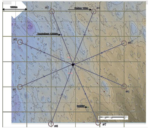
Etter søknadens punkt 2.2 er det mange pockmarks i området. Skal noen av ankerlinene ligge over dem, og hvordan er dette i så fall håndtert i ankringsanalysene?
PSA: A
The Songesand regional seabed is covered by pockmarks of very limited depth and with very low slope gradients, see below maps of anchor spread overlaying maps of pockmarks and bathymetry. Whilst a maximum depth of 8 m was recorded on the site survey, the normal depression depth is typically less than 6 m. For the 8 anchor lines (from anchor to touchdown points) seabed depth variations are typically 2-3m, see bathymetry map below. Accordingly, mooring chains will be in constant contact with seabed and thus the seabed can be treated as flat for mooring analysis purposes.
The planned mooring spread will not be negatively impacted by the spread of pockmarks covering the region.
A check on the worst case ULS load was made. Line 8 will under the 100 year wave scenario have 640 m chain left on seabed which is beyond pockmarks.
[Figure]. Map of pockmarks (in light blue), anchor positions (circles) and the anchors spread.
[Figure] Bathymetry map overlaid by anchor spread
Transocean Arctic
Question
![]()
Etter søknadens punkt 2.2 er det mange pockmarks i området. Skal noen av ankerlinene ligge over dem, og hvordan er dette i så fall håndtert i ankringsanalysene?
Answer
![]()
The Songesand regional seabed is covered by pockmarks of very limited depth and with very low slope gradients, see below maps of anchor spread overlaying maps of pockmarks and bathymetry. Whilst a maximum depth of 8 m was recorded on the site survey, the normal depression depth is typically less than 6 m. For the 8 anchor lines (from anchor to touchdown points) seabed depth variations are typically 2-3m, see bathymetry map below. Accordingly, mooring chains will be in constant contact with seabed and thus the seabed can be treated as flat for mooring analysis purposes.
The planned mooring spread will not be negatively impacted by the spread of pockmarks covering the region.
A check on the worst case ULS load was made. Line 8 will under the 100 year wave scenario have 640 m chain left on seabed which is beyond pockmarks.
[Figure]. Map of pockmarks (in light blue), anchor positions (circles) and the anchors spread.
[Figure] Bathymetry map overlaid by anchor spread
Additional Documentation
 Bathymetry-map-overlaid-by-anchor-spread.png
 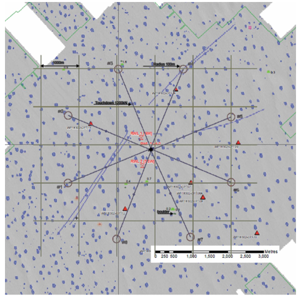 Map-of-pockmarks-in-light-blue-anchor-positions-circles-and-the-anchors-spread.png
EDITOR
CLOSE LL (testing)
New Lesson Learned
-
- PROJECT PHASE
- Operational
- Planning
- Reporting
- CLASSIFICATION
- Positive
- Negative
- Origin
- Own Experience
- Experience Transfer Meeting
- NEA Q&A
- PSA Q&A
- PSA Findings
- DMF
- Norog
-

- RIG
 Borgland Dolphin
- Island Innovator
- Well
 Oselvar
- Gomez
- PROJECT PHASE
- Operational
- Planning
- Reporting
- CLASSIFICATION
- Positive
- Negative
- Origin
- Own Experience
- Experience Transfer Meeting
- NEA Q&A
- PSA Q&A
- PSA Findings
- DMF
- Norog
-

- RIG
- Island Innovator
- Well
- Gråspett
- PROJECT PHASE
- Operational
- Planning
- Reporting
- CLASSIFICATION
- Positive
- Negative
- Origin
- Own Experience
- Experience Transfer Meeting
- NEA Q&A
- PSA Q&A
- PSA Findings
- DMF
- Norog
-

- RIG
- Deepsea Bergen
- WELL
- Brasse
- Rungne
- PROJECT PHASE
- Operational
- Planning
- Reporting
- CLASSIFICATION
- Positive
- Negative
- Origin
- Own Experience
- Experience Transfer Meeting
- NEA Q&A
- PSA Q&A
- PSA Findings
- DMF
- Norog
-

NO LLs for INEOS- RIG
- Borgland Dolphin
- WELL
- Fat Canyon
- PROJECT PHASE
- Operational
- Planning
- Reporting
- CLASSIFICATION
- Positive
- Negative
- Origin
- Own Experience
- Experience Transfer Meeting
- NEA Q&A
- PSA Q&A
- PSA Findings
- DMF
- Norog
-

- RIG
- Deepsea Yantai
- Well
- Shrek
- PROJECT PHASE
- Operational
- Planning
- Reporting
- CLASSIFICATION
- Positive
- Negative
- Origin
- Own Experience
- Experience Transfer Meeting
- NEA Q&A
- PSA Q&A
- PSA Findings
- DMF
- Norog
-

- PROJECT PHASE
- Operational
- Planning
- Reporting
- CLASSIFICATION
- Positive
- Negative
- Origin
- Own Experience
- Experience Transfer Meeting
- NEA Q&A
- PSA Q&A
- PSA Findings
- DMF
- Norog
-
\n\t\t
- \n\t\t\t\t
- All<\/a><\/li>\n\t\t\t\t
- DNO<\/a><\/li>\n\t\t\t\t
- DEA<\/a><\/li>\n\t\t\t\t
- Faroe<\/a><\/li>\n\t\t\t\t
- INEOS<\/a><\/li>\n\t\t\t\t
- PGNiG<\/a><\/li>\n\t\t\t\t
- Wellesley<\/a><\/li>\n\t\t\t\t
- <\/span>Advanced Search<\/a><\/li>\n\t\t\t<\/ul>\n\n\t\t\t
- \n\t\t\t\t
- \n\t\t\t\t\t\n\t\t\t\t\t
\n\t\t\t\t\t\t\n\t\t\t\t\t\t\t
- \n\t\t\t\t\t\t\t\t
- RIG<\/li>\n\t\t\t\t\t\t\t\t
 Deepsea Yantai<\/a><\/li>\n\t\t\t\t\t\t\t\t
Borgland Dolphin<\/a><\/li>\n\t\t\t\t\t\t\t\t
Deepsea Bergen<\/a><\/li>\n\t\t\t\t\t\t\t\t
Deepsea Nordkapp<\/a><\/li>\n\t\t\t\t\t\t\t\t
Island Innovator<\/a><\/li>\n\t\t\t\t\t\t\t\t
Transocean Arctic<\/a><\/li>\n\t\t\t\t\t\t\t\t
Deepsea Yantai<\/a><\/li>\n\t\t\t\t\t\t\t\t
Borgland Dolphin<\/a><\/li>\n\t\t\t\t\t\t\t\t
Deepsea Bergen<\/a><\/li>\n\t\t\t\t\t\t\t\t
Deepsea Nordkapp<\/a><\/li>\n\t\t\t\t\t\t\t\t
Island Innovator<\/a><\/li>\n\t\t\t\t\t\t\t\t
Transocean Arctic<\/a><\/li>\n\t\t\t\t\t\t\t\t
- <\/li>\n\t\t\t\t\t\t\t\t
- Well<\/li>\n\t\t\t\t\t\t\t\t
 Balcom<\/a><\/li>\n\t\t\t\t\t\t\t\t
Brasse<\/a><\/li>\n\t\t\t\t\t\t\t\t
Canela<\/a><\/li>\n\t\t\t\t\t\t\t\t
Fat Canyon<\/a><\/li>\n\t\t\t\t\t\t\t\t
Grosbeak<\/a><\/li>\n\t\t\t\t\t\t\t\t
Grosbeak West<\/a><\/li>\n\t\t\t\t\t\t\t\t
Hemispheres<\/a><\/li>\n\t\t\t\t\t\t\t\t
Kall\u00e5sen<\/a><\/li>\n\t\t\t\t\t\t\t\t
Gr\u00e5spett<\/a><\/li>\n\t\t\t\t\t\t\t\t
Gomez<\/a><\/li>\n\t\t\t\t\t\t\t\t
Oselvar<\/a><\/li>\n\t\t\t\t\t\t\t\t
Rungne<\/a><\/li>\n\t\t\t\t\t\t\t\t
Shrek<\/a><\/li>\n\t\t\t\t\t\t\t\t
Schweinsteiger<\/a><\/li>\n\t\t\t\t\t\t\t\t
Serin<\/a><\/li>\n\t\t\t\t\t\t\t\t
Songesand<\/a><\/li>\n\t\t\t\t\t\t\t<\/ul>\n\t\t\t\t\t\t<\/div>\n\t\t\t\t\t\t
\n\t\t\t\t\t\t\t
Balcom<\/a><\/li>\n\t\t\t\t\t\t\t\t
Brasse<\/a><\/li>\n\t\t\t\t\t\t\t\t
Canela<\/a><\/li>\n\t\t\t\t\t\t\t\t
Fat Canyon<\/a><\/li>\n\t\t\t\t\t\t\t\t
Grosbeak<\/a><\/li>\n\t\t\t\t\t\t\t\t
Grosbeak West<\/a><\/li>\n\t\t\t\t\t\t\t\t
Hemispheres<\/a><\/li>\n\t\t\t\t\t\t\t\t
Kall\u00e5sen<\/a><\/li>\n\t\t\t\t\t\t\t\t
Gr\u00e5spett<\/a><\/li>\n\t\t\t\t\t\t\t\t
Gomez<\/a><\/li>\n\t\t\t\t\t\t\t\t
Oselvar<\/a><\/li>\n\t\t\t\t\t\t\t\t
Rungne<\/a><\/li>\n\t\t\t\t\t\t\t\t
Shrek<\/a><\/li>\n\t\t\t\t\t\t\t\t
Schweinsteiger<\/a><\/li>\n\t\t\t\t\t\t\t\t
Serin<\/a><\/li>\n\t\t\t\t\t\t\t\t
Songesand<\/a><\/li>\n\t\t\t\t\t\t\t<\/ul>\n\t\t\t\t\t\t<\/div>\n\t\t\t\t\t\t
\n\t\t\t\t\t\t\t- \n\t\t\t\t\t\t\t\t
- PROJECT PHASE<\/li>\n\t\t\t\t\t\t\t\t
- Operational<\/a><\/li>\n\t\t\t\t\t\t\t\t
- Planning<\/a><\/li>\n\t\t\t\t\t\t\t\t
- Reporting<\/a><\/li>\n\t\t\t\t\t\t\t\t
- <\/li>\n\t\t\t\t\t\t\t\t
- CLASSIFICATION<\/li>\n\t\t\t\t\t\t\t\t
- Positive<\/a><\/li>\n\t\t\t\t\t\t\t\t
- Negative<\/a><\/li>\n\t\t\t\t\t\t\t\t
- <\/li>\n\t\t\t\t\t\t\t\t
- Origin<\/li>\n\t\t\t\t\t\t\t\t
- Own Experience<\/a><\/li>\n\t\t\t\t\t\t\t\t
- Experience Transfer Meeting<\/a><\/li>\n\t\t\t\t\t\t\t\t
- NEA Q&A<\/a><\/li>\n\t\t\t\t\t\t\t\t
- PSA Q&A<\/a><\/li>\n\t\t\t\t\t\t\t\t
- PSA Findings<\/a><\/li>\n\t\t\t\t\t\t\t\t
- DMF<\/a><\/li>\n\t\t\t\t\t\t\t\t
- Norog<\/a><\/li>\n\t\t\t\t\t\t\t<\/ul>\n\t\t\t\t\t\t<\/div>\n\t\t\t\t\t\t
\n\t\t\t\t\t\t\t- \n\t\t\t\t\t\t\t\t
- TYPE<\/li>\n\t\t\t\t\t\t\t\t
- Equipment<\/a><\/li>\n\t\t\t\t\t\t\t\t
- Planning<\/a><\/li>\n\t\t\t\t\t\t\t\t
- Operational<\/a><\/li>\n\t\t\t\t\t\t\t\t
- Location specific<\/a><\/li>\n\t\t\t\t\t\t\t\t
- Bit<\/a><\/li>\n\t\t\t\t\t\t\t\t
- Logistics<\/a><\/li>\n\t\t\t\t\t\t\t\t
- Mud<\/a><\/li>\n\t\t\t\t\t\t\t\t
- BHA<\/a><\/li>\n\t\t\t\t\t\t\t\t
- Cement<\/a><\/li>\n\t\t\t\t\t\t\t\t
- QHSE<\/a><\/li>\n\t\t\t\t\t\t\t\t
- Sidetrack design<\/a><\/li>\n\t\t\t\t\t\t\t\t
- Time Estimate<\/a><\/li>\n\t\t\t\t\t\t\t\t
- Shallow Gas<\/a><\/li>\n\t\t\t\t\t\t\t\t
- BOP<\/a><\/li>\n\t\t\t\t\t\t\t\t
- Casing<\/a><\/li>\n\t\t\t\t\t\t\t\t
- Connections<\/a><\/li>\n\t\t\t\t\t\t\t\t
- Rig specific<\/a><\/li>\n\t\t\t\t\t\t\t\t
- Coring<\/a><\/li>\n\t\t\t\t\t\t\t\t
- Cut & pull<\/a><\/li>\n\t\t\t\t\t\t\t\t
- Sublease<\/a><\/li>\n\t\t\t\t\t\t\t<\/ul>\n\t\t\t\t\t\t<\/div>\n\t\t\t\t\t\t\n\t\t\t\t\t\t
\n\t\t\t\t\t\t\t- \n\t\t\t\t\t\t\t\t
- Section<\/li>\n\t\t\t\t\t\t\t\t
- P&A<\/a><\/li>\n\t\t\t\t\t\t\t\t
- Top hole<\/a><\/li>\n\t\t\t\t\t\t\t\t
- Surface section<\/a><\/li>\n\t\t\t\t\t\t\t\t
- Reservoir section<\/a><\/li>\n\t\t\t\t\t\t\t\t
- N\/A<\/a><\/li>\n\t\t\t\t\t\t\t\t
- Production section<\/a><\/li>\n\t\t\t\t\t\t\t\t
- Rig move<\/a><\/li>\n\t\t\t\t\t\t\t\t
- Intermediate section<\/a><\/li>\n\t\t\t\t\t\t\t\t
- <\/li>\n\t\t\t\t\t\t\t\t
- DISCIPLINE<\/li>\n\t\t\t\t\t\t\t\t
- Drilling<\/a><\/li>\n\t\t\t\t\t\t\t\t
- HSEQ<\/a><\/li>\n\t\t\t\t\t\t\t\t
- Logistics<\/a><\/li>\n\t\t\t\t\t\t\t\t
- Well test<\/a><\/li>\n\t\t\t\t\t\t\t\t
- Marine<\/a><\/li>\n\t\t\t\t\t\t\t\t
- Rig Intake<\/a><\/li>\n\t\t\t\t\t\t\t\t
- C&P<\/a><\/li>\n\t\t\t\t\t\t\t\t
- External Environment<\/a><\/li>\n\t\t\t\t\t\t\t\t
- Subsea<\/a><\/li>\n\t\t\t\t\t\t\t\t
- Subsurface<\/a><\/li>\n\t\t\t\t\t\t\t\t
- Multi Discipline<\/a><\/li>\n\t\t\t\t\t\t\t\t
- Project Management<\/a><\/li>\n\t\t\t\t\t\t\t<\/ul>\n\t\t\t\t\t\t<\/div>\n\t\t\t\t\t\t\n\t\t\t\t\t<\/div>\n\t\t\t\t\t\n\t\t\t\t<\/li>\n\t\t\t\t
- \n\t\t\t\t\n\t\t\t\t\t\n\t\t\t\t\t
 <\/a>\n\t\t\t\t\t
\n\t\t\t\t\t\t\n\t\t\t\t\t\t\t
<\/a>\n\t\t\t\t\t
\n\t\t\t\t\t\t\n\t\t\t\t\t\t\t- \n\t\t\t\t\t\t\t\t
- RIG<\/li>\n\t\t\t\t\t\t\t\t
- Borgland Dolphin<\/a><\/li>\n\t\t\t\t\t\t\t\t
Island Innovator<\/a><\/li>\n\t\t\t\t\t\t\t\t
- <\/li>\n\t\t\t\t\t\t\t\t
- Well<\/li>\n\t\t\t\t\t\t\t\t
Oselvar<\/a><\/li>\n\t\t\t\t\t\t\t\t
Gomez<\/a><\/li>\n\t\t\t\t\t\t\t<\/ul>\n\t\t\t\t\t\t<\/div>\n\t\t\t\t\t\t
\n\t\t\t\t\t\t\t- \n\t\t\t\t\t\t\t\t
- PROJECT PHASE<\/li>\n\t\t\t\t\t\t\t\t
- Operational<\/a><\/li>\n\t\t\t\t\t\t\t\t
- Planning<\/a><\/li>\n\t\t\t\t\t\t\t\t
- Reporting<\/a><\/li>\n\t\t\t\t\t\t\t\t
- <\/li>\n\t\t\t\t\t\t\t\t
- CLASSIFICATION<\/li>\n\t\t\t\t\t\t\t\t
- Positive<\/a><\/li>\n\t\t\t\t\t\t\t\t
- Negative<\/a><\/li>\n\t\t\t\t\t\t\t\t
- <\/li>\n\t\t\t\t\t\t\t\t
- Origin<\/li>\n\t\t\t\t\t\t\t\t
- Own Experience<\/a><\/li>\n\t\t\t\t\t\t\t\t
- Experience Transfer Meeting<\/a><\/li>\n\t\t\t\t\t\t\t\t
- NEA Q&A<\/a><\/li>\n\t\t\t\t\t\t\t\t
- PSA Q&A<\/a><\/li>\n\t\t\t\t\t\t\t\t
- PSA Findings<\/a><\/li>\n\t\t\t\t\t\t\t\t
- DMF<\/a><\/li>\n\t\t\t\t\t\t\t\t
- Norog<\/a><\/li>\n\t\t\t\t\t\t\t<\/ul>\n\t\t\t\t\t\t<\/div>\n\t\t\t\t\t\t
\n\t\t\t\t\t\t\t- \n\t\t\t\t\t\t\t\t
- TYPE<\/li>\n\t\t\t\t\t\t\t\t
- Equipment<\/a><\/li>\n\t\t\t\t\t\t\t\t
- Planning<\/a><\/li>\n\t\t\t\t\t\t\t\t
- Operational<\/a><\/li>\n\t\t\t\t\t\t\t\t
- Location specific<\/a><\/li>\n\t\t\t\t\t\t\t\t
- Bit<\/a><\/li>\n\t\t\t\t\t\t\t\t
- Logistics<\/a><\/li>\n\t\t\t\t\t\t\t\t
- Mud<\/a><\/li>\n\t\t\t\t\t\t\t\t
- BHA<\/a><\/li>\n\t\t\t\t\t\t\t\t
- Cement<\/a><\/li>\n\t\t\t\t\t\t\t\t
- QHSE<\/a><\/li>\n\t\t\t\t\t\t\t\t
- Sidetrack design<\/a><\/li>\n\t\t\t\t\t\t\t\t
- Time Estimate<\/a><\/li>\n\t\t\t\t\t\t\t\t
- Shallow Gas<\/a><\/li>\n\t\t\t\t\t\t\t\t
- BOP<\/a><\/li>\n\t\t\t\t\t\t\t\t
- Casing<\/a><\/li>\n\t\t\t\t\t\t\t\t
- Planning<\/a><\/li>\n\t\t\t\t\t\t\t\t
- Planning<\/a><\/li>\n\t\t\t\t\t\t\t\t
- Top hole<\/a><\/li>\n\t\t\t\t\t\t\t\t
- Planning<\/a><\/li>\n\t\t\t\t\t\t\t\t
- Planning<\/a><\/li>\n\t\t\t\t\t\t\t\t
- DNO<\/a><\/li>\n\t\t\t\t